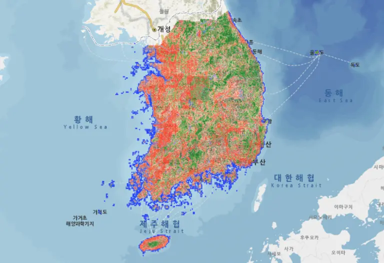
What is Land Cover?
'Land cover' refers to the state of the land in a given area. It is classified into various types such as forests, agricultural land, grasslands, urban and suburban areas, wetlands, water bodies, and barren land. In simple terms, it is the visible surface condition when looking down at the land from satellite or aerial photographs. Changes such as the reduction of forests or the expansion of urban areas directly impact ecosystem health, carbon absorption capacity, water resource conservation ability, and climate mitigation effects. Therefore, land cover surveys are comparable to a 'health check-up' for ecosystems.
Changes in Land Cover in Korea
According to the major classification land cover map from the Ministry of Environment's Environmental Spatial Information Service (EGIS), urbanization has rapidly progressed in Korea since the 1980s. While urban and arid areas have steadily expanded, agricultural areas and some forests and grasslands have shown a declining trend.
In particular, the metropolitan area and surrounding cities have seen a significant increase in urban areas due to the establishment of residential and industrial complexes, with noticeable changes detected at the boundaries of agricultural land and forests. These changes can lead directly to issues such as the urban heat island effect, weakened ability to reduce fine dust, and decreased flood control functions.
According to the National Species List, the number of native species in Korea has increased from about 28,000 species in 1996 to over 61,000 species recently. While the numbers may seem positive, a closer look reveals a complex situation. Endangered species and endemic species continue to decline, and the influx and spread of non-native species are accelerating. Research indicates that the potential for the spread of non-native plants is increasing along roadsides, agricultural lands, and urban areas, posing a threat to native ecosystems.
Climate Change and Ecosystem Stress
Climate change also pressures ecosystems in conjunction with land cover. Research findings show that alpine and temperate plant species in Korea are losing their habitats or moving northward and to higher altitudes. The timing of flowering and leaf emergence is advancing, disrupting the seasonal rhythms of ecosystems and causing mismatches in the life cycles of some insects and birds. Additionally, the increasing frequency of wildfires due to climate change can devastate forests in a short period, often taking decades to recover.
Korea is not yet at the stage where it can definitively state that '60% of the land has surpassed the safe line' like the global average. However, land cover statistics and biodiversity indicators are sending warning signals. A study analyzing the environmental degradation index of the Korean Peninsula found that approximately 30% of the total area was classified as degraded between 2000 and 2022. Notably, the situation in North Korea has deteriorated more rapidly.
The government is promoting the 'Biodiversity Conservation and Utilization Act' and various restoration projects, while some companies are also engaging in ecosystem conservation as part of their ESG activities. However, institutional gaps, lack of prioritization, and regional disparities remain challenges.
It is essential to accumulate and analyze long-term data on land cover changes and biodiversity, actively reflecting this in urban planning, agricultural policies, and forest management. Above all, it is crucial to respond 'before crossing the safe line.' The resilience of ecosystems is not infinite.
The colors of land cover on the map are warning signals sent by the ecosystem. While Korea may still be overall within the safe line, some indicators are already approaching danger. This is why it is necessary for us to closely examine the face of the land and read the changes within it now.

![[Scenario] 2026 Global Wildfire Calendar: The Unending Cycle of Flames](https://cdn.breathjournal.com/w400/q80/article-images/2025-10-01/83cbd0d7-c7c9-4101-b4f6-e39cff028d87.png)



댓글 (0)
댓글 작성